PRHPA
Platte River, High Plains AquiferWho Operates and Manages this LTAR Site?
Andrew Suyker (UNL), Galen Erickson (UNL), Tala Awada (UNL)
Bryan Woodbury (USDA-ARS-MARC, Clay Center) and Brian Wienhold (USDA-ARS-Lincoln)
Description
The Platte River High Plains Aquifer LTAR network is a partnership between the University of Nebraska-Lincoln (UNL) and the USDA-ARS Agro-ecosystem Management Research Unit (AMRU) and the Environmental Management Research Unit (EMRU) in Clay Center, Nebraska. The site was established with a focus on the northern portion of the High Plains Aquifer. This partnership resulted in the establishment of the Platte River – High Plains Aquifer (PR-HPA) LTAR site in 2014. The PR-HPA conducts research to sustain multiple ecosystem services focusing specifically on Nebraska’s main agronomic production agroecosystems that comprise of abundant corn, soybeans, managed grasslands and beef production.
PR-HPA is involved in a combination of ongoing and planned efforts in research pertaining to weather variability while securing a high quality of life in rural and urban communities, as well as maintaining or improving ecosystem services including productivity, biodiversity, soil health, air and water quality. PR-HPA emphasizes sustainable intensification based on the adoption of conservation agriculture principles including reduced soil disturbance, cover cropping, precision agriculture, livestock integration within the cropping system and improved beef production systems through management of genetics, forage quality and pasture fertilization.
Geography
The Platte River High Plains Aquifer PR-HPA Long-Term Agroecosystem Research (LTAR) conducts research at the UNL’s Eastern Nebraska Research and Extension Center. The irrigated and rainfed croplands as well as the pasture sites are located within 41.18° N latitude and -96.44° W longitude, 360 asl). The datum used to represent the site include: UTM Zone 14/ NAD 83/ Nebraska State Plane. The UTM zone is Zone 14N. The major land resource area of ecoregion is Nebraska and Kansas Deep Loess Hills. The topography of the PR-HPA land is gently sloping (0-2% slope) with soils characterized as Sharpsburg silty clay loam of pH 6.6 and soil organic matter (SOM) of approximately 2.8%.These soils are deep and moderately well drained soils that formed in loess. The consist of the soil orders: Alfisols, Entisols, and Mollisols
Instrumentation
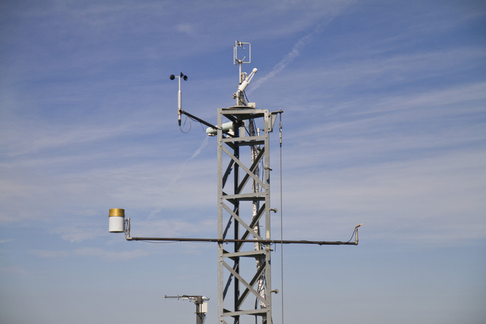
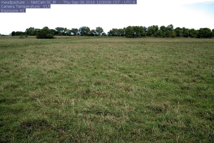
The instrumentation at the PRHPA consists of 5 eddy covariance towers (4 located in Mead, Nebraska and the most recent, in a pasture at MARC near Clay Center that is part of PRHPA LTAR . These provide meteorological data as well as sensible heat (energy), water and CO2 measurements of flux under both pasture and croplands sites. The PRHPA LTAR also has 4 phenocam cameras administered by PhenoCam Network – housed at the University of New Hampshire https://phenocam.sr.unh.edu/webcam/. Soil temperature probes, rain gauges are also included as part of the instrumentation. Data is saved in dataloggers and saved at the UNL East Campus server.
Instruments utilized by PRHPA for data collection.
| Name | Brand | Model |
| Pyranometer | Kipp & Zonen | CNR1 |
| Sonic Anemometer | Gill | R3-100 |
| Net Radiometer | Kipp & Zonen | CNR1 |
| Quantum Sensor | LI-COR | LI-190SA |
| Infrared Gas Analyzer | LI-COR | LI-7200 |
| Open Path Gas Analyzer | LI-COR | LI-7500A |
| Wind Speed Sensor | Met One | 010C |
| Net Radiometer | Kipp & Zonen | CNR1 |
| Tipping Bucket Rain Gauge | Texas Electronics | TE-525 |
| Temperature/Humidity Probe | Vaisala | HMP50Y |
| Barometric Pressure Sensor | LI-COR | LI-7500A |
| Soil Heat Flux Plate | Radiation and Energy Balance Systems | HFT3 |
| Thermistor | ACI | Bullet |
Classification System
Farm Resource Regions: Nebraska and Kansas Deep Loess Hills
Land Resource Region: M – Central Feed Grains and Livestock Region
Hydrologic Unit Codes (HUC-2): Region 10
National Ecological Observatory Network (NEON): Domain D14 (Desert Southwest)
NRCS Major Land: 106
LTAR Research Emphases
- Sustainable use of the High Plains (Ogallala) Aquifer, focusing on water discharge and recharge, ground and surface water interactions, water quantity and quality.
- Sustainability and resiliency of forests, grasslands and agroecosystems from weather variability, and anthropogenic management.
- Sustainable development and resilience of rural and urban communities under growing needs for ecosystem services including water, food, feed, fuel and fiber.
- Agroecosystems resiliency, thresholds and shifts, mitigating and adapting to dynamic weather.
- Biological, ecohydrological and biochemical processes in grasslands, forests and agroecosystems under variable weather, vegetation cover change (including invasive species and human activities.
- Water vapor and carbon dioxide fluxes in natural and agroecosystems.
- Close-range, field, and airplane based phenotyping using hyperspectral imaging systems to evaluate natural and agroecosystem productivity, processes, cover and vegetation shifts in response to environmental conditions and management practices.
- Data integration, testing, scaling of models from grid to macroecosystems.
Muti-site Initiatives
- Common experiment synthesis (Spiegal/Bestelmeyer)
- Water balance (Baffaut)
- Phenocam (Browning)
- Crop classification and remote sensing (Coffin)
- Eddy Covariance (Alfiero)
Collaborations
PRHPA is a partnership between the University of Nebraska-Lincoln (UNL) and the USDA-ARS Agro-ecosystem Management Research Unit (AMRU) and the Environmental Management Research Unit (EMRU) in Clay Center, Nebraska. It collaborates with federal agencies, units within UNL, ARS location on research that is funded by grants aligned with the mission and goals of LTAR. Scientists affiliated with PRHPA are actively involved in multi-location research objectives:
Measurements from eddy covariance towers from the three main carbon sequestration Project sites are archived and shared from the Ameriflux: The AmeriFlux network is a community of sites and scientists measuring ecosystem carbon, water, and energy fluxes across the Americas, and committed to producing and sharing high quality eddy covariance data. AmeriFlux investigators and modelers work together to generate understanding of terrestrial ecosystems in a changing world. “ http://ameriflux.lbl.gov/
- Resilient Economic Agricultural Practices (REAP) https://www.ars.usda.gov/anrds/reap/reap-home/
- Greenhouse Gas Reduction through Agricultural Carbon Enhancement Network (GRACEnet) https://www.ars.usda.gov/anrds/gracenet/gracenet-home/
- The Center for Advanced Land Management Information Technologies (CALMIT)
- The National Drought Mitigation Center (NDMC)
Major Accomplishments
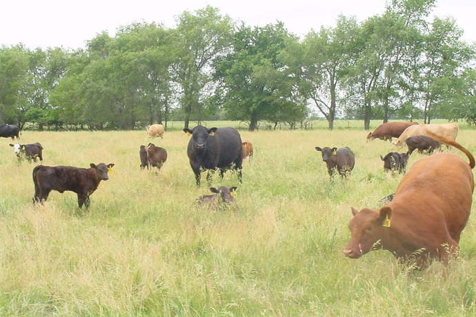
Rangelands Common Experiment
We have a pasture site where evaluations of management practices on beef production, impacts on ecosystem services, profitability and sustainability are being studied.
Accomplishments
- Effects of animal genetics, nutrition and soil fertilization are being tested specifically.
- Livestock performance of about 23 cattle grazing in pasture have been measured.
- Body weight and animal daily gain have been measured over 2 years.
- Diet samples have been stored to measure protein and energy content.
Croplands Common Experiment
PR-HPA has three sites that consist of:
- Irrigated Continuous corn
- Irrigated Corn-soybean rotation
- Rainfed corn-soybean rotation
Accomplishments
More than 15 years-worth of data has been collected from these sites ranging from solar radiation, eddy covariance measurements, biometerological data (e.g. precipitation, temperature, Leaf Area Index (LAI), yield, biomass, soil fluxes, evapotranspiration etc.)
Eddy Covariance/Flux
Four eddy covariance towers are installed at the sites in Mead. Three of the towers (installed in 2001) are located in the 3 cropland experimental sites while one tower is located at the pasture site (installed in 2005). Instrumentation on the towers include an infrared gas analyzer and an ultrasonic anemometer. These are used for measuring land-atmosphere fluxes and concentrations.
Accomplishments
- PR-HPA has more than 15 years-worth of eddy covariance data.
- Several publications have been published using these data.
- Purchase of a high precision dual quantum cascade laser trace gas analyzer from Aerodyne to measure trace greenhouse gases.
Meteorology
Four eddy covariance towers are installed at the sites in Mead. Three of the towers (installed in 2001) are located in the 3 cropland experimental sites while one tower is located at the pasture site (installed in 2005). Alongside flux instrumentation on these towers, are several instruments installed to measure precipitation, air temperature, air pressure, solar radiation, wind speed, soil temperature.
Accomplishments
More than 15 years-worth of data has been collected from the cropland sites.
Non CO2 gases
Accomplishments
- Greenhouse gases have previously been measured in PRHPA’s cropping sites using micro-chambers from point sources and is already published.
Soils
PR-HPA has conducted biological, chemical and physical tests to characterize soils from the sites.
Accomplishments
- An internal UNL grant award facilitated members of PR-HPA to study soil microbial diversity and abundance tests on soils taken from the sites.
- Soil samples were also collected, processed and analysed by Oklahoma’s LTAR to assess soil microbial diversity.
- Poster presentation to be made at the NSPSS Annual Meeting and Symposium February 2, 2018.
- Manuscript in preparation on the PRHPA soil microbial and abundance experimental study.
Other Networks (where data is shared)
- Ameriflux
- AgData Commons
Site Name
Platte River, High Plains Aquifer, Nebraska
Website
Location
Nebraska
Established
2014
Area (km2)
Approximately 2.4 km2
Leader(s)
Virginia Jin and Marty Schmer (ARS), Tala Awada (UNL)


ABOUT LTAR
The USDA Agricultural Research Service (ARS) Long-Term Agroecosystem Research network consists of 18 Federal and university agricultural research sites with an average of over 50 years of history. The goal of this research network is to ensure sustained crop and livestock production and ecosystem services from agroecosystems, and to forecast and verify the effects of environmental trends, public policies, and emerging technologies.