LCB
Lower Chesapeake BayDescription
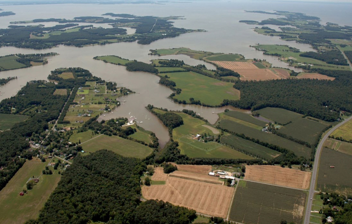
The Lower Chesapeake Bay (LCB) LTAR consists of roughly the southern half of the Chesapeake Bay watershed and physically contains the entire Chesapeake Bay estuary. Agricultural lands are dominant on the eastern shore and are intermingled with significant urban areas (including Washington, DC and Baltimore, MD) west of the Bay. It is characterized by physiography ranging from the Coastal Plain to the east to the Piedmont, Blue Ridge, and Ridge and Valley provinces to the west. Elevations in much of the eastern part of the LCB are near sea level and increase to approaching 1000 m in the extreme western Ridge and Valley province. LCB is humid subtropical with annual rainfall generally ranging between 900-1100 mm and a mean annual temperature around 12°C. Research is conducted at a set of intensive research fields at the Beltsville Agricultural Research Center (BARC) and at multiple scales of parallel and nested watersheds in the Choptank River watershed on Maryland’s eastern shore. Studies in some of these locations date to as early as 1910.
LCB-LTAR research involves improving agronomic practices, collecting field and remotely-sensed data, and developing and evaluating models and decision support tools. It is managed by a number of research units in Beltsville, Maryland: Hydrology and Remote Sensing Laboratory (HRSL), Sustainable Agricultural Systems Laboratory (SASL), and Adaptive Cropping Systems Laboratory (ACSL). The overall goals of the LCB-LTAR are to:
- Provide a venue to explore beneficial opportunities and to minimize the negative aspects of the agriculture-urban interface;
- Enhance the ecological benefits and services provided by agricultural lands in the protection and restoration of the Chesapeake Bay watershed;
- Develop adaptive strategies for agricultural production systems in response to extreme weather changes within the vulnerable coastal region;
- Develop decision-support tools to implement effective, efficient, and economically-viable agricultural systems, land and water resource management, and conservation practices;
- Build upon existing partnerships with agencies, universities and non-governmental organizations to achieve programmatic goals; and
- Establish and maintain standardized laboratory and data management systems for critical analyses to ensure consistency and availability of long-term data records.
Several major long-term field experiments are conducted at BARC. Results from these study sites inform larger experiments carried out throughout the LCB-LTAR often in collaboration with farmers and producers.
- Cover Crop Systems Project (CCSP, est. 2009): The aim of CCSP is to assess cover crop-based, reduced-tillage conventional and organic grain production systems and to evaluate their potential to improve farm production sustainability, conserve/enhance soil resources, minimize potential for multiple herbicide-resistant weeds, and maximize agroecosystem services. Core measurements include crop yields; crop and weed biomass and nutrient contents; cover crops, weed population, and community dynamics; soil fertility and quality; soil carbon and nitrogen to 1 m depth; greenhouse gases; soil moisture; management records; and economic performance.
- Farming Systems Project (FSP, est. 1996): The emphasis of FSP is to examine the benefits and risks of organic and conventional farming. The overall design consists of four replicated blocks with each of the five rotation entry points present each year. Several microplot experiments have been added to compare the effects of weeds, crop varieties, and soybean nitrogen fixation. Core measurements include: crop yields; crop and weed biomass and nutrient contents; cover crops, weed populations; soybean nitrogen fixation; soil fertility and quality; soil carbon and nitrogen to 1 m depth; greenhouse gases; soil moisture; management records; and economic performance.
- Optimizing Production Inputs for Economic and Environmental Enhancement (OPE3, est. 1998): This site consists of a 22 ha production field with an adjacent riparian wetland and first order stream. The site is equipped with a fully instrumented eddy-covariance flux tower with phenocam, soil moisture sensor network, groundwater wells, runoff catchments, and stream weirs. In addition, the site is monitored by several remote sensing platforms and serves as a validation site for remote sensing of soil moisture enhancing the value of the co-located NRCS SCAN monitoring site. Together these systems allow for detailed monitoring of subsurface, surface, and atmospheric processes and characterization of water and chemical behavior. The infrastructure also provides a meaningful evaluation of processes at the field scale and allows for comparison of site specific management techonologies. The research site is large enough to capture the spatial variability of crop and soil parameters, yet not so large that the fields themselves are in different climatic or geologic settings.
- BARC production fields: The production fields at BARC are a unique asset within the LCB LTAR. These fields, approximately400 hectares in area, are used to produce hay, feed, and generate modest commercial revenue to support BARC’s animal operations and overall budget. A new initiative undertaken by LCB is to incorporate these fields into our data collection to develop and test new site specific management technologies, test innovative cropping systems at landscape scale and assess water quality impacts of conservation practices.
- Controlled Environmental Studies: Experimental systems for exposing crops and weeds to altered environmental conditions. These include outdoor, naturally sunlit chambers referred to as SPAR (Soil Plant Atmospheric Research) units (1 m2), which provide precise control of the major environmental factors influencing plant growth, including temperature, humidity and carbon dioxide concentration. The SPAR units are fully automated to measure canopy gas exchange including photosynthesis, respiration and water use. Root compartments have windows which allow root growth to be monitored. There are several of lamplit indoor growth chambers, many of which have CO2 control as well. These are best suited to container studies. Our outdoor, field facilities include six open top chambers (3 m2) which are instrumented to control CO2. We are also working on controlling temperatures within a narrow range. Finally, facilities include four Free Air Carbon Enrichment (FACE) rings.
Research efforts in the Choptank River watershed are driven by the broad goal of assessing of agroecosystem services provided by water management, conservation practices, and wetland systems. A paired subbasin monitoring design facilitates comparison of water use and nutrient dynamics over rain-fed and irrigated agricultural landscapes under similar weather conditions. In-situ turbidity, nitrate, total organic carbon, and dissolved organic carbon measurements are acquired at the Tuckahoe and Greensboro headwater subbasins, which are defined by the drainage areas sampled at the co-located USGS gauging stations. Monthly water samples are collected at fifteen subwatersheds and analyzed for nutrient and pesticide content. A fully instrumented eddy-covariance flux towers is located on an irrigated cropland field in the Choptank River watershed and meet LTAR requirements. Natural, restored and drained wetlands are instrumented to monitor wetland hydroperiod gradients associated with a landscape ditch drained to support row crop production and assess impacts of altered biogeochemical gradients on carbon storage and methane emissions. Network standard phenocam hardware monitor cropland and wetland vegetation growth on the restored wetland sites. Ten soil moisture meteorological monitoring stations have been installed on private lands distributed throughout the Choptank River watershed. These data are used in parameterization of distributed process models.
Classification System
Farm Resource Regions: Southern Seaboard, Eastern Uplands, and Northern Crescent
Major Farm Region:
Hydrologic Unit Codes (HUC-2): Region 02 (Mid-Atlantic)
National Ecological Observatory Network (NEON): Domains D02 (Mid-Atlantic)
NRCS Major Land: Northern Atlantic Slope Diversified Area, Atlantic and Gulf Coast Lowland Forest and Crop Region
LTAR Research Emphases
- Remote sensing of soil moisture, evapotranspiration, and crop yield targeted to both the LCB and the entire LTAR network
- Flux towers
- Water quality and quantity measurement and modeling
- Cropping systems
Muti-site Initiatives
Using MESA to Date Agricultural Waters
Groundwater residence time is critical to understanding the effectiveness of conservation practices in remediating excessive nitrogen. However, most water dating techniques cannot be used to date open-waters, such as stream water, because the techniques use volatile compounds in the atmosphere that are transferred to groundwater. A new groundwater dating technique discovered by BARC scientists uses the change in the chirality of MESA, a metabolite of the widely-used herbicide metolachlor. The approach takes advantage of the change in chiral composition of the applied herbicide product, which occurred around 2000. Metolachlor degrades to MESA without alteration to the chiral centers. Furthermore, MESA is formed in the vadose zone with nitrate, co-leaches to the groundwater, is very water soluble, and conserved making it an ideal tracer for assessing fate of agriculture nitrogen.
A new passive sampling method of MESA was recently developed. Several POCISs (polar organic chemical integrative sampler) were placed at two locations in the Choptank River watershed to determine the ideal sampling window. Beginning in late spring 2018, samplers will be deployed at seven locations across the network to test the robustness and applicability of this technique to other stream waters.
Major Accomplishments
List of accomplishments
Other Networks (where data is shared)
- Ameriflux
Site Name
Lower Chesapeake Bay
Website
https://www.ars.usda.gov/northeast-area/beltsville-md-barc/beltsville-agricultural-research-center
Location
Beltsville, Maryland and Choptank Watershed (Eastern Shore of Maryland)
Established
1910
Area (km2)
Various scales ranging from 0.1 km2 to 2000 km2
Leader(s)
LCB Site: Michael Cosh (Site Lead), Joe Alfieri, Martha Anderson, Michel Cavigelli, Wade Crow, David Fleisher, Lisa Fultz, Feng Gao, Eunjin Han, Cathleen Hapeman, W. Dean Hively (USGS), Bill Kustas, Jude Maul, Gregory McCarty, Steven Mirsky, Clifford Rice, Harry Schomberg, Zach Smith, Dennis Timlin
Broad LTAR Network: Michel Cavigelli, Michael Cosh, Cathleen Hapeman, Greg McCarty, Jude Maul, W. Alex White
ABOUT LTAR
The USDA Agricultural Research Service (ARS) Long-Term Agroecosystem Research network consists of 18 Federal and university agricultural research sites with an average of over 50 years of history. The goal of this research network is to ensure sustained crop and livestock production and ecosystem services from agroecosystems, and to forecast and verify the effects of environmental trends, public policies, and emerging technologies.