Data Overview
About data efforts in the LTAR NetworkLTAR Data Collection and Management
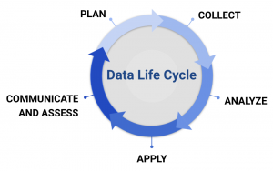
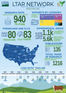
LTAR scientists are responsible for managing a rich legacy of data spanning over seven
Maintaining data integrity and usability at a time when data streams are growing exponentially is challenging. When well-documented and good quality data is made easily available through responsive and nimble data infrastructure, the speed of science can be accelerated.
Who Manages the Data?
LTAR accelerates the speed of science from research conception to product creation by having dedicated data managers embedded in the research process. Data managers ensure that best practices and standards for the collection, documentation, and storage of data are collaboratively developed within the network, and then met at their LTAR site. These practices facilitate data sharing by publishing datasets to repositories and/or visualizing them through online systems.
With data managers at each site in the network, scientific data are no longer in file cabinets, but in systems that make data and information accessible to scientists and the public.
What Types of Data Do We Collect?
LTAR Network data come from various sources, including:
- sensors programmed to measure meteorological and hydrological dynamics
- time-series data produced from the field, laboratory and sensors
- records of agricultural management practices
- analysis of detailed imagery of landscapes from satellites
- samples and specimens – biological, genomic, and soil samples that are archived at individual LTAR sites, as well as national and regional ARS laboratories
- wearable technologies to assess livestock behavior and location
- and other measurements made directly in the field and in laboratories
LTAR scientists also utilize data that was collected by other organizations, collaborators and partners. These include:
- USDA partners such as the Economic Research Service, Natural Resource Conversation Service, and the U.S. Forest Service
- Geospatial atlases such as ESRI’s Living Atlas, IPCC’s Interactive Atlas, and PolicyMap
- Other geospatial aggregators such as USGS’ The National Map, NASA/USGS’ Landsat archives, and Google Earth Engine
- Weather aggregators such as NOAA and FAWN
Advances in how data can be collected and managed are researched by LTAR scientists and data managers with the support of ARS’ Partnerships for Data Innovation.
LTAR has a complete inventory of data produced by each of the 18 LTAR sites. This data inventory can also be explored by using the LTAR Data Inventory Insights Dashboard.
How Do Scientists Use Data?
Scientists use LTAR Network data to make long-term observatories of various conditions within the agroecosystems being studied. Data are also produced to measure effects of treatments in experimental studies. Data help scientists interpret the impacts of innovations they are studying under various agricultural management practices.
Scientists need to access data quickly, and to be able to compare data from multiple sites. Common metadata, or useful information about the data, are used to make the data findable, and link data from multiple sites and other data repositories to LTAR. An inventory of datasets begin collected by LTAR Network sites can be found here.
How Can I Access LTAR Network Data?
Some resources for accessing and/or visualizing LTAR data include:
- LTAR has a complete inventory of data produced by each of the LTAR sites and the location of some of these datasets can be obtained from the “URLdataAccess” field in the inventory or by contacting the the person(s) in the”ResponsiblePerson” column.
- Ag Data Commons, which is hosted by the National Agricultural Library and serves as an aggregator and portal for all published data from agricultural research in USDA, including LTAR sites.
- Online visualizations, dashboards and other exploratory tools developed by LTAR Network.
- The Agricultural Genetic Resources Preservation Research Unit, which provides security for genetic materials used in agriculture.
- Ameriflux, a network of individually managed sites that measure ecosystem CO2, water, and energy fluxes. Several LTAR sites contribute greenhouse gas flux data to Ameriflux.
- The PhenoCam Network, housed by the University of New Hampshire, which provides near real-time canopy phenology images photographed every half hour at several LTAR (as well as other) sites.
ABOUT LTAR
The USDA Agricultural Research Service (ARS) Long-Term Agroecosystem Research network consists of 18 Federal and university agricultural research sites with an average of over 50 years of history. The goal of this research network is to ensure sustained crop and livestock production and ecosystem services from agroecosystems, and to forecast and verify the effects of environmental trends, public policies, and emerging technologies.

